
While political and some business interests attempt to propagandize a Climate Change agenda, the fact is there are huge amounts of untapped fresh water, and it can be precisely located.

Mainstream corporate media, naive Barack Obama-Hillary Clinton holdover believers and Biden Crime Family apologists don’t like this to be mentioned, but just recently, a huge new source of good water, in an aquifer, was discovered in south Texas.
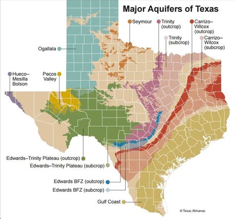
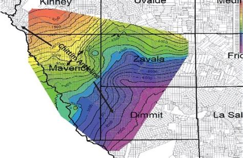
The newly named Maverick Basin Aquifer is known to be at least 3,000 square miles and averages 1,000 feet thick in most places. This comes years after government and academic water experts concluded Texas’ deeper aquifers are brackish (salty) at best.
Water tests on this new aquifer show it comes out of the ground already meeting or exceeding federal and state drinking water standards!
Texas is in it’s second year of an estimated three-year study to determine if Maverick Basin will be an official aquifer. The initial studies on the last officially designated aquifer, Cross Timbers Aquifer in north-central Texas took about a year to complete.
The US National Groundwater Association estimates there is 6,000 years of freshwater supply in the upper two kilometers of the earth’s crust link.
Meanwhile, the Biden Administration does little, if nothing, to mitigate America’s water woes.
They are too busy advancing special interest climate agendas: electric cars, “smart” 5G controlled appliances, the purposeful decline of oil, gas and energy sourcing, etc.
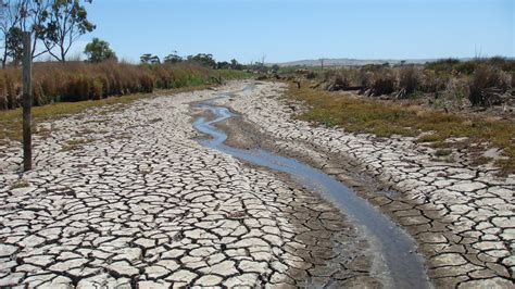
In the meantime, up on the surface, the most recent Seasonal Assessment from the US National Weather Service indicates a continuing “distinctive pattern to the changes in the Drought Monitor.”

“Broadscale improvement was noted across affected areas in the Northeast, the Mid-Atlantic Region, the Middle Mississippi Valley, the central Plains, and most of the Great Lakes,” noted forecaster Rich Tinker.
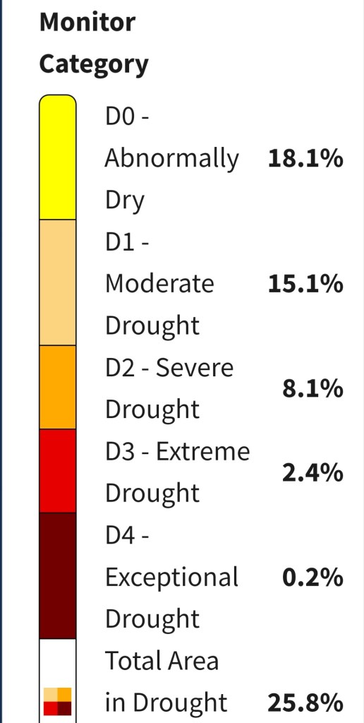
In July, dramatic improvements were up to “3 categories were noted in some areas near the Mississippi/Ohio Rivers’ confluence and near the Great Lakes Region.”
Current Drought Conditions in US
• 1,860 counties with crops experiencing drought (D1–D4)
• 262.6 Million acres of crops experiencing drought (D1–D4)
• 18.8 Million beef cattle experiencing drought (D1–D4)
• 646 counties with drought declarations
________________
“Meanwhile, similar broadscale deterioration occurred from the Upper Mississippi Valley westward into the Pacific Northwest, and along the southern tier of states from the Desert Southwest eastward through the Lower Mississippi Valley.”
“A few areas in northwestern New Mexico and the central and southern portions of Texas saw severe intensification by up to 3 Drought Monitor categories.”
“Excessive heat made a significant contribution to the current drought conditions along the southern tier of states, and to a lesser extent the Pacific Northwest.”
“The southern Plains and Lower Mississippi Valley felt the worst of the heat, and Excessive Heat Warnings were frequent during the past month, especially along the central and western Gulf Coast Region.”
“Lakefront Airport in New Orleans reported heat indexes topping 115F every day during August 5-15, topping out at 124F late afternoon on the 15th. For 69 hours, from 7:15 CDT August 7 through 3:45 CDT August 10, the heat index remained at or above 100F.”
“Drought intensification was also observed in Hawaii, contributing to fatal wildfires that scorched parts of Maui.”
Tinker observed that the surge of tropical moisture – partially fueled by Tropical Storm Hilary – has been pushing into the Southwest, from the southeastern California deserts to eastern Arizona.
“This should bring some relief from dryness that has developed during the hot and drier-than-normal Southwest Monsoon,” he reported.

“The dwindling patches of drought from the Appalachians to the Atlantic Coast are also expected to ease, along with the areas of drought currently affecting the Virgin Islands, Puerto Rico, and Alaska.”
For the rest of the country, not much relief is expected outside the most severely affected areas in extreme [D3] drought across the Upper Midwest.
Heat and a lackluster Monsoon should keep drought intact along the southern tier of the country from the Southern Rockies through the central Gulf Coast Region, with some development expected in parts of the Four Corners Region, across central and northeastern Texas, and in northern Louisiana.”
“Drought is also expected to persist and locally worsen from the Upper Mississippi Valley westward through the Pacific Northwest, with some expansion in the latter region, where the wet season beginning in late October is expected to get off to a slow start.”
“Also, drought is expected to persist and develop across Hawaii, with all but central and eastern Kauai expected to be in moderate drought [D1 or worse] by the end of autumn.”
The reality of this all, goes against the grain of New World Order, World Economic Forum and globalist billionaire agendas.
Controlled media avoids the news that there are new and proven advanced technologies locating sources of fresh water right now.
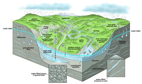
This includes Deep Seated Water, which is groundwater typically sourced from deep aquifers that are located lower than shallow aquifers.
Such deep aquifers are supplied not only from local catchment basins but also by subsurface inflows across basin boundaries. Deep Seated Water also encompasses water created at the mantle level of the Earth under extreme heat and pressure.
Multicomponent geospatial analysis, satellite imagery, geologic and hydrologic examination are used along with on-the-ground instrumentation and a variety of other data sources to locate the depth, estimated amount and flow rate of freshwater sources.
This is a stark contrast from the large percentage of groundwater locators who still use “water witching” or “dowsing” to try to find water. That’s why the reported success rate of finding water that way is in the range of 40% whereas newer technologies are now approaching 100%. This practically eliminates the possibility of drilling an expensive “dry hole”.
☆☆☆☆☆
IN GOD WE TRUST

Thanks for supporting independent true journalism with a small tip. Dodie & Jack
Green Pasture Here!

Use Code CLEVER10 for a 10% discount on other Green Pasture products today!


CINDY LEAL MASSEY, TEXAS AUTHOR
________________


This is so sad. They don’t want us to find it or use it. Do you think weather machines are causing this extreme heat (for political purposes)?
LikeLiked by 5 people
I’m leery of elites who manipulate weather, but have found no definite proof.
LikeLiked by 4 people
I worked in a Steel Mill related Industry. Walking through work one day, being a Birder, being fond of Trees, being casually into Amateur Astronomy, and being a Weather Watcher, I tend to look up. What did I see beyond the pipes and conduit of work? A Jet Airplane, Contrails streaming out of the engines. But as I watched, the Contrails Stopped. Then Started again. Then Stopped. Then Started. It’s possible it was a Chem Trail, and they were manipulating the output. I looked for signs of Shear, to see if it was a Contrail that was diffused by winds, but the edges remained perfect, sharply cut, as if something was turned on and turned off. I told my boss, an intelligent man, and he scoffed, saying they were Contrails. When I told him I saw them turning On and Off a number of times, he looked confused and had no more to add.
Looking now, I see the American Search Engines help the govt to push their narrative. So I used Yandex. This Russian Based Search Engine can be used to look for things being censored by the American Search Engines, but try to click on known sites, such a Twitter (X), known publications, etc., or use a Site Checker for the Link before visiting it.
That said, I quickly found this:
𝙄𝙣 𝘾𝙖𝙡𝙞𝙛𝙤𝙧𝙣𝙞𝙖’𝙨 𝙈𝙤𝙪𝙣𝙩 𝙎𝙝𝙖𝙨𝙩𝙖 𝙧𝙚𝙜𝙞𝙤𝙣, 𝙁𝙧𝙖𝙣𝙘𝙞𝙨 𝙈𝙖𝙣𝙜𝙚𝙡, 𝙖 𝙐𝙎𝘿𝘼 𝙒𝙞𝙡𝙙𝙡𝙞𝙛𝙚 𝘽𝙞𝙤𝙡𝙤𝙜𝙞𝙨𝙩 𝙖𝙣𝙙 𝙬𝙖𝙩𝙚𝙧 𝙨𝙥𝙚𝙘𝙞𝙖𝙡𝙞𝙨𝙩 𝙝𝙖𝙨 𝙧𝙚𝙥𝙤𝙧𝙩𝙚𝙙 𝙚𝙡𝙚𝙫𝙖𝙩𝙚𝙙 𝙡𝙚𝙫𝙚𝙡𝙨 𝙤𝙛 𝙖𝙡𝙪𝙢𝙞𝙣𝙪𝙢, 𝙗𝙖𝙧𝙞𝙪𝙢, 𝙖𝙣𝙙 𝙨𝙩𝙧𝙤𝙣𝙩𝙞𝙪𝙢 𝙞𝙣 𝙩𝙝𝙚 𝙢𝙤𝙪𝙣𝙩𝙖𝙞𝙣’𝙨 𝙨𝙣𝙤𝙬, 𝙥𝙤𝙡𝙡𝙪𝙩𝙞𝙣𝙜 𝙙𝙧𝙞𝙣𝙠𝙞𝙣𝙜 𝙬𝙖𝙩𝙚𝙧, 𝙧𝙞𝙫𝙚𝙧𝙨 𝙖𝙣𝙙 𝙨𝙤𝙞𝙡 𝙞𝙣 𝙩𝙝𝙚 𝙖𝙧𝙚𝙖.
The significance is I saw a video with govt officials disclaiming Chem Trails, and they were asked a question about these substances, above (some or all, I no longer remember) being elevated in areas where they would not expect to be found at all. The govt spokesperson just ignored them.
I have seen that when the Govt is spraying to Induce Weather Events, that when a Storm Warning is issued, they can continue spraying for 1/2 an Hour past the storm warning. I think they are doing something. I’m from the Govt and I’m here to help is a Well Known Contradiction.
LikeLiked by 2 people
Thank you!
LikeLiked by 2 people
I understand. Still not sure how I feel or what I believe. I have prayed about it so much. And I just tell God, “I trust You…whether it’s You or them. Because You’re still in control of it all.”
LikeLiked by 3 people
He is.
LikeLiked by 2 people
“Oh-O, yes indeed we know, that people will find a way to go, no matter what the Man says” because God puts it in us to hope and hang on and trust Him. Streams in the desert; I hope they can put them to work soon. It’s been such a hard time.
LikeLiked by 2 people